MILFORD SOUND FIORDLAND SOUTH NEW ZEALAND
A Travelogue
By
VIKRAM KARVE
Milford Sound is Awesome
Nowadays – it has become a fashion – especially among youngsters – to use the word “awesome” for anything and everything.
If you want to understand (and visualize) the true meaning of the word “awesome” – you should visit MILFORD SOUND – nestled in the UNESCO-listed Fiordland National Park in South New Zealand.
“Awesome” refers to an overwhelming thrilling feeling of amazement combined with fear or wonder.
Milford Sound is Awesome.
In good weather – the breathtaking landscape of Milford Sound inspires exhilarating feelings of wonder.
(Luckily – we visited Milford Sound on 27 December 2015 – a bright clear sunny day – in the best of weather – so we experienced “awesome wonder”)
Our guides at Milford Sound told us – that – we were fortunate that the weather was so good on that day – because – in rough weather – the sky becomes overcast – there are heavy winds and torrential rains – and the sea becomes terribly turbulent – the atmosphere becomes so frighteningly eerie and terrifyingly scary – that – the same Milford Sound induces a “fear-provoking awesomeness”)
So – whether it overwhelms you with feelings of extreme fear or intense wonder –Milford Sound is Awesome.
Fiordland
Milford Sound is located in Fiordland.
One of the world’s vast wildernesses of untamed splendor – Fiordland is New Zealand’s largest National Park comprising a magnificent landscape of soaring snow-covered peaks, glistening fiords, beautiful lakes, untamed waterfalls, virgin forested valleys, and fast-flowing rivers winding through native forest.
Fiordland is located on the South West Coast of the South Island of New Zealand – and is a “must see” destination for anyone visiting New Zealand.
Cloud-piercing cliffs, snowcapped mountains, lush rainforest and spectacular waterfalls adorn this glacier-carved pristine wilderness. The fiords and lakes, deepest in New Zealand, are amazing. In Fiordland – the sea water is permanently covered by a layer of fresh water as a result of heavy rainfall and run-off water flowing downwards from glaciers – and – due to this – there is extraordinary marine life in Fiordland. While fiords can be upto 400 meters deep – marine life tends to occupy only the top 40 meters – so you can see dolphins, seals and penguins.
“A cherished corner of the world where mountains and valleys compete with each other for room, where scale is beyond comprehension, rainfall is measured in metres and scenery encompasses the broadest width of emotions” – this is how the author of the book “Mountains of Water – The Story of Fiordland National Park” described this stunning National Park.
The extraordinary beauty, unique topography and physical grandeur of Fiordland is a result of the enormous natural power of water – glaciers created the stunning landscape by carving out the sheer faces of the fiords and chiseling out the valley floors to form deep lakes – and so – water is the predominant facet in the beauty of Fiordland – awesome glaciers and rugged peaks in the midst of picturesque lakes, rivers, waterfalls, lush rainforests and stunning fiords.
Are they “Sounds” or “Fiords”
Fiordland’s west coast is deeply indented by 14 fiords spanning 215 kilometers of coastline. You see an awesome sight of steep mountains rise up from the ocean.
The Fiordland area was well known to the Maori – but there were hardly any permanent residents due to the rugged landscape and unpredictable turbulent weather conditions in Fiordland which lies between Latitudes 44 and 47 degrees South (The “Roaring Forties”). The Maori established well worn trails linking seasonal food-gathering camps and gathered koko-takiwai, a translucent gemstone found in the area.
Captain Cook and his crew were the first Europeans to visit Fiordland and in 1773 they spent 5 weeks in ‘Dusky Sound’. Captain Cook’s maps and descriptions soon attracted sealers and whalers who formed the first European settlements of New Zealand. In mid-19th century – explorers, surveyors and prospectors began to explore and discover the unexplored interiors of Fiordland.
These early European explorers saw the spectacular sight of steep mountains rising from the ocean creating deep water-filled valleys – and they called these water-filled valleys as “Sounds” and gave them various names (Milford Sound, Doubtful Sound, Dusky Sound etc).
However – in the case of these water inlets from the sea – the word “Sound” was a misnomer – because a true “Sound” is a river valley that has been flooded due to the land sinking below sea level – whereas “Fiords” is created by glacial action that produces U-Shaped valleys with steep cliffs – as is the case in Fiordland. Hence – “Fiords” is the correct terminology to describe these “Sounds” (Milford Fiord, Doubtful Fiord, Dusky Fiord etc).
The confusion in calling “Fiords” as “Sounds” may be due to the fact that many of the early sailors who discovered this area were of English and Welsh origin and were not familiar with Fiords – and named these “Fiords” as “Sounds”. This misnomer while naming the famous “Sounds” continued as a legacy, but the region was renamed “Fiordland” to recognize the true nature of these rugged water inlets from the sea.
Legendary History of Fiordland
There is a Maori legend regarding the formation of Fiordland. According to Maori legend, Tu-te-raki-whanoa carved out the fiords with his adze (right angled axe) Te Hamo. He started in the far south where he created a rough coastline with many islands. By the time he reached ‘Milford Sound’ he had perfected his technique and carved an awe-inspiring fiord which he called Piopiotahi (Milford Sound) which was his greatest achievement.
Milford Sound is the northernmost and most accessible of the fiords – by the spectacular Milford Road – which begins from Te Anau, skirts the western bank of lake Te Anau, meanders through Eglinton Forest, climbs up to glacier dominated mountains, then, goes through the long Homer Tunnel under the Southern Alps, after which the road descends sharply to sea level to Milford Sound.
It is said that Rudyard Kipling referred to Milford Sound as the “Eighth Wonder of the World” when he visited at the turn of the 20th century – but it was only after the opening of the 1.2 km long Homer Tunnel in 1954 that tourists could easily access the fiord. Once you visit the awesome Milford Sound, you will realize why Milford Sound has been called the “8th Wonder of the World”.
Visit to Milford Sound
We visited Milford Sound on the 27th of December 2015 – luckily it was a bright summer day with clear sky and lovely weather.
We opted for the Milford Sound “Coach and Cruise” Day Tour – which includes a 10 hour road journey by comfortable sightseeing bus from Queenstown to Milford Sound and back – and a scenic cruise of 2 hours sailing around the entire Milford Sound from Milford Wharf to the Tasman Sea and back.
The road journey from Queenstown to Milford Sound and Back to Queenstown covers around 600 kilometers.
Milford Sound is to the west – not very far from Queenstown – ‘as the crow flies’.
However – the terrain between Queenstown and Milford Sound is very mountainous and extremely rugged due to which it was impossible to build direct roads through the mountains.
Hence – you have to travel south from Queenstown – take a long and scenic detour to the South – then travel north past Eglinton Valley – before heading west through the Homer Tunnel and then down to Milford Sound. The road is quite narrow and winding – a challenging drive – and – if you want to enjoy the trip – it is best to travel by bus – the luxury coaches have big windows and glass roofs for an excellent view of the stunning scenery.
Though the bus journey is quite long – it takes around 5 hours to reach Milford Sound – luckily – it is through some of the world’s most beautiful scenery – with plenty of comfort stops for sightseeing – and – this makes the trip memorable.
PART 1 : QUEENSTOWN TO MILFORD SOUND – STUNNING SCENERY
Unforgettable Road Journey to Milford
During our visit to New Zealand’s South Island, we had based ourselves at Queenstown, Southern Hemisphere’s premier Alpine Resort, a beautiful town situated on the shores of crystal clear Lake Wakatipu, surrounded by glacier rounded hills and rugged mountain peaks.
(In case I get an opportunity to visit New Zealand again – I shall spend a day or two at Te Anau – which will give me an opportunity to visit other attractions of Fiordland like ‘Doubtful Sound’ and indulge in some “tramping” in the Fiordland National Park – and then – also see Southland (Southern South Island) – drive on the Southern Scenic Route – and visit Invercargill, Bluff, Stewart Island, The Catlins, Dunedin etc)
On the day of our visit to Milford Sound (27 Dec 2015) – the Milford Sound Day Tour Bus departed at 7 AM from our hotel in Queenstown. We crossed the one lane Kawarau River Bridge – and then – we traveled south beside the iconic Remarkables mountain range (one of only two mountain ranges in the world that run directly north to south) to the east – and Lake Wakatipu to the west.
Lake Wakatipu is the longest lake in New Zealand (80 kilometers long) and very deep (between 378-420 meters deep in some places). According to Maori legend – Lake Wakatipu was formed when the body of a sleeping giant was burnt by a Maori warrior, who wanted to ensure the giant could never again kidnap his beautiful daughter. The fire burned a deep gouge in the earth and caused the ice and snow on the surrounding mountains to melt, forming Lake Wakatipu.
After passing through the towns of Kingston (at the southernmost point of Lake Wakatipu), Athol and Lumsden (I wonder whether the famous Lumsden Freehouse in Newmarket Auckland is named after this town) – the bus turns west to travel through rural countryside toward Te Anau. On the way – the bus crosses Mossburn (the self-proclaimed deer capital of New Zealand) – then the road follows the Oreti River – then continues into the hills – passes through undulating tussock lands and valleys – before emerging back onto the plains – eventually bringing us to the lakeside town of Te Anau.
After the drive of more than 2 hours, there is a comfort and refreshment halt at Te Anau – and it is advisable to “refresh” yourself well with food and drink here – so that you are ready for the long day ahead. The lovely town of Te Anau is nestled on the shore of Lake Te Anau – the largest lake in South Island of New Zealand – and – as I said earlier – Te Anau is the ideal base to explore Fiordland.
Milford Road
After Te Anau – our bus headed north – through the Fiordland National Park – to Milford Sound – a spectacular alpine drive of almost 3 hours – to cover 120 kilometers – from Te Anau to Milford Sound on a beautiful finest scenic highway.
The entire area is a sanctuary of fauna and flora and underwater environment and a part of the Te Wahipounamu World Heritage Area – so – for a good part of the Milford Sound Road Trip you will be out of cell phone range or wi-fi coverage (since you will be in the wilderness).
The bus travels on Te Anau lake shoreline before entering the spectacular golden grassed Eglinton Valley. Thereafter – the bus stops at various scenic points to enable you to enjoy the awesome natural beauty and take photographs for memory.
Our driver (who doubled up as a guide) gave us a lively commentary throughout the journey, showing us the captivating sights, and giving us a wealth of information on the history, flora and fauna of the region, and he also showed us some of the locations where ‘The Lord of the Rings’ Trilogy was filmed.
(New Zealand’s dramatic scenery – golden plains, towering mountains and enchanting valleys – plays the mythical world of ‘Middle-Earth’ on the big screen in The Lord of the Rings and The Hobbit Trilogy. More than 150 locations throughout the country were used to film The Lord of the Rings and The Hobbit Trilogy)
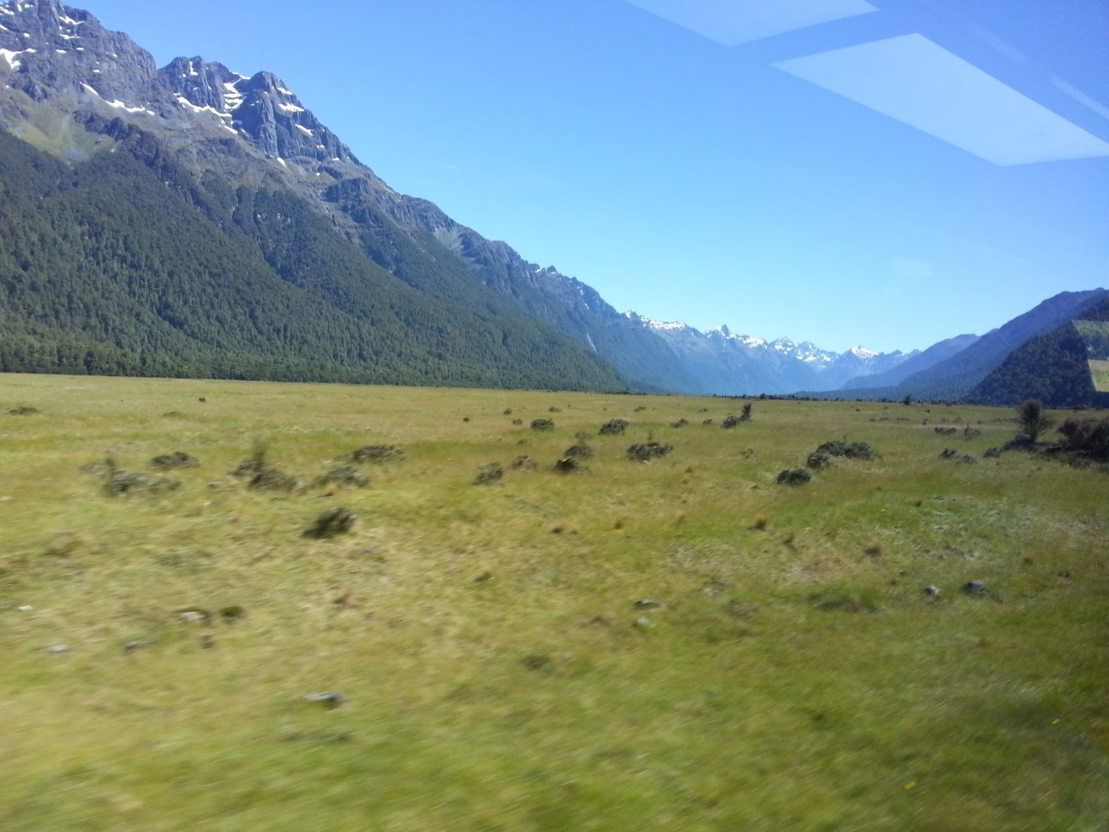
The Eglinton Valley is the first major highlight of the Milford Sound Road. It was once filled with glacier ice. The valley has steep rock sides and a flat, golden tussock floor and is a surreal place where the road penetrates steeper into bush-clad mountains. Then we saw stunning sights like Mirror Lakes, in which you can see a perfect reflection of the Earl Mountains, the ‘Avenue of the Disappearing Mountain’, where an optical illusion causes the approaching mountain to get smaller rather than larger, Knobs Flat, at the end of the forest, and Cascade Creek.
Then we headed through bush clad valleys on the shores of Lake Gunn and Lake Fergus – and then – the road passes through ‘The Divide’ – past a saddle – and emerges at the upper section of the Hollyford Valley. The driver told us that the Eglinton Mountains above Lake Gunn were used as a location for the movie The Fellowship of the Ring – and the mountains here represented the Misty Mountains.
After Hollyford – the road rises steadily along the valley to its highest point at the Homer Tunnel. On this road we witnessed remnants of landslides from the glaciers above – with glacial snow almost hugging the road.
The Homer Tunnel looks quite “eerie” – a dark narrow hole in the towering Southern Alps. Completed in 1953, the 1270 meter long Homer Tunnel pierces the sheer rock to allow access to Milford Sound across the high snow capped mountain range. At an altitude of 945 meters above sea level, the tunnel is hewed out of solid granite – an extraordinary achievement – the tunnel took nearly 20 years to complete. The tunnel has remained unmodified since its creation, has limited internal lighting which makes it dark inside, and it is quite narrow in width and small in height, which entails one-way traffic. So – the bus waits for green light to indicate we can pass through the blackness of the narrow tunnel – while we enjoy the view of the ice-debris of a glacial landslide beside the road.
After we cross the Homer Tunnel – there is a spectacular view of the road winding down the verdant Cleddau Valley towards Milford Sound. The bus stops at a scenic place called ‘The Chasm’ – where there is a walkway through the forest and footbridges over The Cleddau River – and you can see breathtaking views of powerful waterfalls and sculpted shapes and basins in the rock, which have been formed over thousands of years by the swirling waters.
(The construction of the Milford Road section began in 1926 when John Chartres, a local Station owner, began making his own road south from Te Anau Downs Harbour to the Te Anau Hotel, sparking a project that turned into the most scenic highway in New Zealand including iconic landmarks such as the Mirror Lakes, the Avenue of Disappearing Mountain, Lake Gunn, the Key Summit, Mount Christina, Mount Talbot, the Homer Tunnel, The Chasm, Mount Tutoko and Mitre Peak. It was made a proper state highway in the 1980’s.
It was a major undertaking to build the Milford Road, and it took nearly 30 years until both the gravel road and Homer Tunnel were finished in 1954. No-one thought it was an appealing job to work in the remote wilderness of Fiordland, being subject to all kinds of wild weather, floods, snow, avalanches, so most of the men who worked on the road were more or less forced by the Government to take the jobs up during the Great Depression.
The section from Te Anau to ‘The Divide’ was completed in the 1930. Work on the Homer Tunnel began in 1935. Difficult conditions, and a break during World War II, delayed the completion until 1953. The road was sealed in the 1980’s and the last stretch of the road was finally completed in 1992)
Soon – we skirt the Milford Sound ‘Freshwater Basin’ (a small ‘harbour’ which contains more freshwater than saltwater and was named accordingly) – and the bus disembarks us at the Cruise Terminal at the Wharf – where we embark on board The Pride of Milford, a large catamaran.
It is almost 1 PM in the afternoon when we reach Milford Sound – we have traveled for almost 6 hours from Queenstown – but the stunning scenery made the journey so enjoyable – which bears testimony to the saying: “The Milford Road isn’t just a journey – it’s a destination in itself”.
We took many photos during the journey on Milford (and I may post a separate photo-blog on our visit to New Zealand and Milford Sound) – but – just to give you an idea of the scenery – here a few pictures we took on our journey on the Milford Road.

Milford Road


Eglinton River

Eglinton River Valley

Reflection of Earl Mountains in Mirror Lake
Knobs Flat
(In the distance you can see the Southern Alps Mountain Range which you have to cross through Homer Tunnel to reach Milford Sound)

Landscape on Climb to Homer Tunnel

Glacial Landslide

Glacial Ice remnants from a Landslide
(waiting for Green Light outside Homer Tunnel)

Bus Waiting to enter Homer Tunnel

Landscape to West of Homer Tunnel

Climbing Down Southern Alps towards Sea Level

Road Descends towards Milford Sound

Waterfall in "The Chasm" Forests near Milford Sound

View from The Chasm

Crossing Cleddau River near Milford Sound

Milford Sound Freshwater Basin
(Milford Wharf is just across the hill)
PART 2 : MILFORD SOUND SCENIC CRUISE
Background
Around 180 million years ago New Zealand broke away from a giant landmass called Gondwana and drifted nearly 3,000 kilometers south to its present location.
Till the 1300s – New Zealand was uninhabited – and no human had visited these islands.
Polynesians sailed here in the early 1300s, following their ancestor Kupe, who had named the country “Aotearoa” – “Land of the Long White Cloud”.
Dutch explorer Abel Tasman arrived in 1642 – naming the land “Nieuw Zeeland”.
European settlement began in 1769 with the arrival of British Navigator Captain James Cook.
However – Fiordland was still undiscovered by the Europeans.
Fiordland’s west coast is deeply indented by 14 fiords spanning 215 kilometers of coastline – and you see an awesome sight of steep mountains rise up from the ocean.
The Fiordland area was well known to the Maori – but there were hardly any permanent residents due to the rugged landscape and unpredictable turbulent weather conditions in Fiordland which lies between Latitudes 44 and 47 degrees South (The “Roaring Forties”). The Maori established well worn trails linking seasonal food-gathering camps and gathered koko-takiwai, a translucent gemstone found in the area.
More than 4 years after landing in New Zealand – Captain Cook and his crew were the first Europeans to visit Fiordland in 1773 – and they spent 5 weeks in ‘Dusky Sound’.
Captain Cook’s maps and descriptions soon attracted sealers and whalers who formed the first European settlements of New Zealand.
In mid-19th century – explorers, surveyors and prospectors began to explore and discover the unexplored interiors of Fiordland.
Are they “Sounds” or “Fiords” (also spelt “Fjords”)
These early European explorers saw the spectacular sight of steep mountains rising from the ocean creating deep water-filled valleys – and they called these water-filled valleys as “Sounds” and gave them various names (Milford Sound, Doubtful Sound, Dusky Sound etc).
However – in the case of these water inlets from the sea – the word “Sound” was a misnomer – because a true “Sound” is a river valley that has been flooded due to the land sinking below sea level – whereas “Fiords” is created by glacial action that produces U-Shaped valleys with steep cliffs – as is the case in Fiordland.
Hence – “Fiords” is the correct terminology to describe these “Sounds” (Milford Fiord, Doubtful Fiord, Dusky Fiord etc).
The confusion in calling “Fiords” as “Sounds” may be due to the fact that many of the early sailors who discovered this area were of English and Welsh origin and were not familiar with Fiords – and named these “Fiords” as “Sounds”.
This misnomer while naming the famous “Sounds” continued as a legacy, but the region was renamed “Fiordland” to recognize the true nature of these rugged water inlets from the sea.
Legendary History of Fiordland
There is a Maori legend regarding the formation of Fiordland.
According to Maori legend, Tu-te-raki-whanoa carved out the fiords with his adze (right angled axe) Te Hamo.
He started in the far south where he created a rough coastline with many islands.
By the time he reached ‘Milford Sound’ he had perfected his technique and carved an awe-inspiring fiord which he called Piopiotahi (Milford Sound) which was his greatest achievement.
The Goddess of the underworld, Hine-nui-te-po, came to see the place and was so alarmed at seeing the awesome beauty of Piopiotahi, that she got worried that once people see this magnificent fiord they would be so attracted by it beauty that they would settle down here and spoil the pristine beauty of the place.
So – to deter humans from settling down here – she released the ‘Sandfly’ into Milford Sound.
(Sandfly is an insect which bites human beings).
Maybe – that is why there is a place called “Sandfly Point” where the Arthur River enters the Milford Sound.
The Maori called the fiord ‘Piopiotahi’ after the thrush-like piopio bird, now extinct.
Welsh Settlers baptized it with the current name after ‘Milford Haven’ in Wales.
Rudyard Kipling called it the “Eighth Wonder of the World.”
As explained earlier – Milford Sound isn’t actually a ‘Sound’ but a “Fiord” – an inlet of the Tasman Sea – the length of Milford Sound is more than 12 Kilometers - it is 7.5 miles long – and the depth is upto 400 meters – with an average of around 320 meters (1,050 feet) deep.
8th Wonder of the World
Milford Sound is the northernmost and most accessible of the fiords – by the spectacular Milford Road – which begins from Te Anau, skirts the western bank of lake Te Anau, meanders through Eglinton Forest, climbs up to glacier dominated mountains, then, goes through the long Homer Tunnel under the Southern Alps, after which the road descends sharply to sea level to Milford Sound.
Cloud-piercing cliffs, snowcapped mountains, lush rainforest and spectacular waterfalls adorn this glacier-carved pristine wilderness. The fiords and lakes, deepest in New Zealand, are amazing. In Fiordland – the sea water is permanently covered by a layer of fresh water as a result of heavy rainfall and run-off water flowing downwards from glaciers – and – due to this – there is extraordinary marine life in Fiordland. While fiords can be upto 400 meters deep – marine life tends to occupy only the top 40 meters – so you can see dolphins, seals and penguins.
It is said that Rudyard Kipling referred to Milford Sound as the “Eighth Wonder of the World” when he visited at the turn of the 20th century – but it was only after the opening of the 1.2 km long Homer Tunnel in 1954 that tourists could easily access the fiord. Once you visit the awesome Milford Sound, you will realize why Milford Sound has been called the “8th Wonder of the World”.
Milford Sound Scenic Cruise
We visited Milford Sound on the 27th of December 2015 – luckily it was a bright summer day with clear sky and lovely weather.
We opted for the Milford Sound “Coach and Cruise” Day Tour – which includes a 10 hour road journey by comfortable sightseeing bus from Queenstown to Milford Sound and back – and a scenic cruise of 2 hours sailing around the entire Milford Sound from Milford Wharf to the Tasman Sea and back.
The road journey from Queenstown to Milford Sound and Back to Queenstown covers around 600 kilometers.
The Road Journey has been described in Part 1 of this travelogue: MILFORD ROAD
Now – let me tell you about the scenic cruise in Milford Sound.
Since I do not have words to describe the awesome beauty of Milford Sound – I will post a few pictures which I clicked on my smartphone for you to appreciate – with a bit of description.
Our cruise vessel was a Catamaran named ‘PRIDE OF MILFORD’
 |
| Pride of Milford |
The cruise started from the small “harbour” in the Freshwater Basin (which thanks to the inflow the Arthur and Cleddau Rivers and glacial streams – contains more freshwater than saltwater from the sea – and so is named accordingly).
 |
| Freshwater Basin |
 |
| Milford Sound Cruise Begins |
In front of us – we had a spectacular view of the fiord with the 2, 014 meter high snowcapped Mount Pembroke towering majestically above – the glacier on Mount Pembroke is the remnant of the glacier which carved its way through the fiord and is upto 27 meters in depth.
 |
| Fiords and Mountains |
Several streams from the melting snow flow down into the fiord – giving it a layer of freshwater which sits on top of the seawater facilitating the unique marine life found here in Milford Sound.

The cruise vessel then skirted the southern side of the fiord via scenic sights like the 161 meter high “Bowen Falls”.
Then we see a hanging valley called “Sinbad Gully” on the slopes of Mt Phillips.
 |
| Sinbad Gully (a Hanging Valley) |
Of course – dominating the landscape is the 1692 meter high Mitre Peak – the highest mountain in the world to rise directly from the ocean floor – which resembles a Bishop’s Mitre (headdress)
 |
| Mitre Peak |
We then cruise past mountains called “The Lion” and “The Elephant” because of their shapes.
 |
| Lion (Left) Elephant (Right) with Mt Pembroke in background |
Then – sailing through the narrowest section in the fiord called “Copper Point”because of very high deposits of copper found on the slopes. This narrow part of the fiord is very windy – wind gusts in excess of 140 kmph have been recorded here.


 |
| Copper Deposits on Mountainside |
Then we saw one of the prettiest parts of the fiord – “Fairy Falls” – which have a natural rainbow.
 |
| Fairy Falls |
 |
| Mitre Peak and Fairy Falls from Tasman Sea Side |
Now – the fiord opens up towards the Tasman Sea at Dale Point – via “Anita Bay”(where Maori explorers visited for greenstone) – and “St Anne’s Point” at the entrance to fiord where the Milford Sound Lighthouse is located.
 |
| Sailing Towards Dale Point (Entrance to Milford Sound from Tasman Sea) |


 |
| Anita Bay (Tasman Sea can be seen ahead) |
 |
| Entrance to Milford Sound Fiord from the Tasman Sea |
 |
| St. Anne's Point on Tasman Sea |
Once we reached the Tasman Sea – the cruise vessel made a broad sweep and then turned around – and here – where the fiord meets the sea – we saw a few Dolphins jumping out of the water.
 |
| Tasman Sea |
 |
| Can you spot the Dolphin wake |
On the way back – the cruise vessel skirted the northern side of the fiord.

We stopped at “Seal Rock” we saw a number of Fur Seals basking on the rock.
 |
| See the Seals on the Rock to the left and in front |
 |
| Seals Basking in the sun at Seal Rock |
Then we saw the 155 meter high majestic “Stirling Falls” (the vessel got so close that we were almost drenched under the waterfall)
 |
| Stirling Falls |
Then – we entered Harrison Cove (which has an underwater observatory)
 |
| Harrison Cove (See the "Titanic Style" Honeymoon Couple LOL) |

 |
| Milford Sound Discovery Centre and Underwater Observatory |


Soon we were back at the Milford Sound Cruise Wharf to disembark from the boat and board our bus for our return journey via Homer Tunnel and Te Anau to Queenstown.


Dear Reader:
I had planned to write this travelogue in one go.
But – as you can see – it is became too long.
And – I wrote PART 2 pertaining to the awesome Cruise in Milford Sound today.
I have written this travelogue based on my own personal experience during my visit to Milford Sound on 27 December 2015 – of course – I have referred to Visitor Guides and Tourism Sites for cross-checking and background information.
However – all the photographs in the travelogue have been clicked by me on my smartphone.
VIKRAM KARVE
Copyright © Vikram Karve
1. If you share this post, please give due credit to the author Vikram Karve
2. Please DO NOT PLAGIARIZE. Please DO NOT Cut/Copy/Paste this post
© vikram karve., all rights reserved.
1. If you share this post, please give due credit to the author Vikram Karve
2. Please DO NOT PLAGIARIZE. Please DO NOT Cut/Copy/Paste this post
© vikram karve., all rights reserved.
Copyright © Vikram Karve (all rights reserved)

This Blog Post is a combination of my blog posts on MILFORD SOUND posted by me online earlier at urls: http://karvediat.blogspot.in/2016/02/milford-sound-is-awesome-travelogue.html and http://karvediat.blogspot.in/2016/02/milford-sound-scenic-cruise.html
No comments:
Post a Comment